
Mount Service is one peak in a series of mountains forming a geographic border between the Nanaimo Watershed and the Cowichan Valley. It’s most commonly accessed from the Cottonwood Main, just outside Youbou, but it’s also a fun hike from the other side. However, because it’s inside the Nanaimo Watershed and just south of Jump Lake, the area is usually closed. In order to access the area, one must be certified by the municipality, and access it during hunting season. Considering all of the challenges that can prevent access to this route, when Rod asked me to join him on a trip inside the watershed I jumped at the chance!

Mount Service Map and GPS track
Total Distance: 9 km
Starting Elevation: 664 m
Maximum Elevation: 1485 m
Total Elevation Gain: 937 m
Total Time: 4 h 20 m
Rod picked me up at 4:30 am on the morning of November, 12th. The rain fell by the bucket-load onto our vehicle and it showed no sign of letting up by the time we reached the Jump Main gate. It was raining so hard that it was difficult to see the gate attendant through the rain-covered windshield. Rod rolled down his window and produced his watershed certificate for the attendant; after a brief conversation, the gatekeeper recorded our information and waved us through.
We drove the long bumpy road along Jump Lake’s northern shore, winding around to the east and over Jump Creek before finding ourselves driving south over the deteriorating road. It was still dark as the truck roared with the effort of climbing the steep hills. We crossed a number of washouts, then paused at a large ephemeral waterfall before deciding to back down, park (~500m), and continue on foot.
The morning light was just breaking as we walked the last 500 metres of the logging road. We jumped up the embankment into the old-growth, at a section where the old-growth touched the road. The defoliated remains of low-standing blueberry brushed our legs as we hiked up the remarkably open terrain. Though there isn’t an established route, we found many game trails that travelled up the steep hill.
Around 950 meters, we popped out up over an embankment and discovered an old road grade. Apparently, in the darkness of the early morning, we made an error and parked much lower than we could have. I can’t say I was disappointed because I enjoyed the approach through the old-growth; it was a great warm-up, and frankly more enjoyable than walking a long stretch of gravel road.
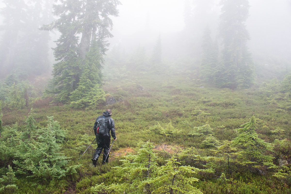
We only stuck to the road for a few hundred metres more before heading up into the next stand of old-growth forest. The bush became dense as we climbed, but it took only a moderate effort to push past the low-hanging branches. On our way up this second hill, the rain softened to a light mist that would persist for the remainder of the day. We continued on the path of least resistance, using a short gully below the ridge to scramble up and over a band of rock.
The lightly-treed ridge (1035 m) is narrow enough to see the hill drop off on either side. On a clear day, I’m sure the view would be spectacular; today, the cloud obscured the valley’s secrets. At times, we followed more game trails through spindly, leafless shrubs. We found periodic signs of human activity, such as degraded, bleached ribbons tied to tree limbs. Eventually, we mounted a bump on the ridge (~1180). It was marked with two rocks: someone had been here!

The day’s biggest challenge was descending from the bump to the col between it and Mount Service’s summit. The terrain is built on a series of small ledges, and though mostly it was possible to descend on a series of ramps, at one point we needed to use tree branches to ease ourselves down a three-metre wall.
Once at the saddle between the bump and Mount Service, the terrain opened up into low-alpine meadow. The mist ensured we could only see several hundred meters in front of us, but it was enough for us to plot a simple walk up to a high bluff that the summit sits atop of.
As we approached I queried my topo, but Rod was confident in his route-finding. He wandered to the base of the rock and cut left. We found another booted path that keeps tight against the rock, and rounds the mountain while it gains elevation. It’s a good Class 2 route with only two small steps that some may find airy. We were nearly there! Finally, we could see the top of Mount Service, just beyond a ledge or two. We wound between ancient stunted trees, seeking the summit. It was cold, so we moved quickly to get to our cairn. As we stepped onto the summit, a strong cold wind cut into us. I looked all around, but the cloud obscured any reasonable view; the driving rain and cold wind motivated me to step off the summit into the cover of the rock below.

Edging along the bluff leading up towards the summit
We were both very cold, and decided it was better to keep moving to keep our temperature up rather than freeze. We descended back to the saddle, following our approach route. After a quick snack, we worked our way back along the ridge. We passed by the gully we used to scramble up the rock band, continued along the easy-to-walk ridge, and followed it down to toe of the ridge toward the road that emerged below.

Rod on the summit

Descendin off the ridge to the logging road
As we stood at the top of our final hill, we could see a weather station below us, in a wide clearing amongst replanted trees. Our route took us to it, but the final 100 metres was spent pushing through the dense regrowth. We forced our way to the station and looked around, but we couldn’t figure out its mysteries. We took one final moment to look off into the valley below, then followed the nearby road back to the truck.
It was definitely a wet day in the mountains. By the time I reached the truck, I was soaked to the bone: my boots were the only dry piece of equipment. Nevertheless, I’m happy that I braved the weather to take a shot at the route to Mount Service from the Nanaimo Watershed. I’m sure I won’t often have that opportunity.
Comments
Hi there,
My name is Chelsea and I work for the Marmot Recovery Foundation. We are looking into hiking routes to Mount Service to survey for the Vancouver Island marmot. I am just wondering if you still had access to the GPS track for this trip, and if you would be willing to share it?
Thanks!
Chelsea