Winter sent a confusing message in early March. There was obvious evidence of winter’s demise, and I even wrote a few posts saying so. But then winter made a roaring comeback, with some ski hills receiving as much as 200cm of snow. Although this is great news for spring skiing, it makes planning adventures a bit more challenging.
On Sunday, March 6, we intended to adventure in the Bonanza Range, with a goal of summiting Mount Ashwood. With the recent snow and poor layer adhesion earlier in the year, the avalanche risk was set to extreme. After assessing the risk, and our beta for the trip, we changed our plan and picked another mountain: Mount Russell. It’s located north of Campbell River, but not as far as Woss. Another long day in the car was inevitable, but the juice was definitely worth the squeeze, as Phil would say.
In many of my trip reports, I write about getting into situations that require a rope for descending, walking along exposed ridges, or setting protection in the rock in order to reach a summit. In comparison, Mount Russell is an uncomplicated route, ending with some fantastic ridgewalking. For folks looking to get into the high alpine without the exposure that many other peaks on Vancouver Island entail, this is a series of bumps to check out.
 |
| Mount Russell GPS route and Map |
Distance: 10 km
Starting Elevation: 815 m
Maximum Elevation: 1749 m
Elevation Gain: 949 m
Time: 6h 15m
Like many other Vancouver Island peaks, the route to Mount Russell starts somewhere down a logging road. The road is in better than average condition, and we were able to navigate the small cross-ditches and make it to 850m in elevation before stopping at the snowline on the road.
The familiar crunch of snow beneath my snowshoes, and the growing line behind me, gave me a good feeling for the start of the day. By 8:00 am we were well on our way, quickly traveling the first few kilometres of snow-covered logging road. Snow depth soon piled high. The condition was good for snowshoeing, as the snow didn’t collapse much as we walked. The warmer weather of the week before gave it good consolidation, and it remained that way for the day.
We were following a GPS route that starts with a steep ascent off an old watercourse at the terminus of the logging road; however, we deviated well before the end of the road. Stepping off the logging road, we traversed up the barren snow slope to the treeline; undoubtedly, the slash lay buried deep below the blanket of snow. We soon reached and moved in through the treeline. An easy land bridge crosses well above the gully that presents at the beginning of the route, and we reconnected with the route we were using.
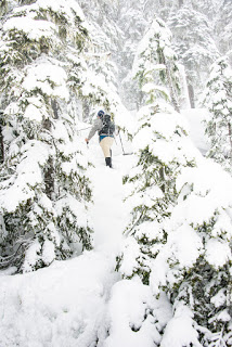
Phil took the lead as we progressed up the hill through mature hemlock forest. We found no evidence of trail markings, and I couldn’t say whether the route is booted; there may be one buried in the deep snow. A light snow fell on us as we worked our way up through the steep old growth. Before long, we were hot inside our waterproof breathables, and we stripped down to our t-shirts.
 |
| Snow encrusted old growth, a feast for the eyes |
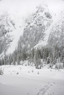
The route through the mature forest is steep, and we crossed a trickling watercourse a number of times on our way up the hill. The lightly falling snow and ancient trees made for an enchanting walk, and the silence of the winter forest is always a welcome treat. Around 1200m, we reached a 10-metre-tall headwall. We stayed to the right and quickly found our way through more gnarled old trees to what lay above, emerging onto an open plateau (the summer route we used traversed left of the headwall). Easy navigation over rolling snow drifts gave hints of better things to come. Only a few snow-encrusted copses of trees adorned the snow-covered landscape.
We stood in awe. Ahead, the prominent ridge protected a deep snow-engulfed cirque. The snow was pristine: not one set of tracks marred the landscape. We crossed the rolling snowdrifts, easily working our way toward a gully that gives access to the ridge above. Looking back, we could see our trail, which reminded me of an illustrator’s pencil mark on a clean sheet of paper. It was perfect.
The light snow continued, but the overcast sky seemed to be breaking; the sun even hinted at shining. Cerulean patches were visible through the blowing clouds that obscured the summit. As we walked, we were gently buffeted by small gusts of wind. Above us, however, we could see windy curls of snow created as the gusts hit the crests of the snow bumps.
 |
| rocky ridge in the distance, the summit on the right beyond the visible crest |
Phil and I examined the route ahead. Comprehending depth was a challenge, as the even light of the overcast day obliterated all form in the landscape. On more than one occasion we stopped and stared hard at our next step to see if we were about to step downhill. From the base of the ridge, we looked for the best route up. We compared the landscape to the route we had, and chose a different approach to the ridge.
While ascending the steep snow slope, the conditions exploded in our face. Not only did the hill get steeper than we expected, but we were hit by the full force of the wind. As the strong winds buffeted me, I wavered, driving my poles deep into the slopes for self-belay, ensuring that if I slipped in my snowshoes I wouldn’t slide down the hill. We could see a large exposed rock face, and scrambled to it; as we reached it, the wind blasted us again.
Small ice shards pummeled our exposed skin and froze to our glacier glasses. The glasses soon became useless: foggy on the inside, icy on the outside. The only thing they offered was protection from the flying ice, keeping it from hitting our eyes. We stood with our backs to the wind, leaning into it. I could see the snow curl past me; the void I created sent swirls of snow twirling past me. In better weather, I would have moved to the right around the rock, but the wind and snow prevented us from doing so; we were forced to go to the left.
 |
| visibility 0, check his glasses |
We were close to the summit; on a better day, I imagine we could have reached it in just 10 or 15 minutes. Once we rounded the rock outcropping, we were fully exposed to the wind and snow, with gusts exceeding 60 km/h. With each blast we were pushed forward, forced to hold on for balance. We briefly took shelter behind two frozen trees; after examining our maps and GPS to get a bearing, we moved blindly toward the summit.
 |
| Add caption |
The snow and wind were at our backs as we were pushed higher on the summit ridge. I was forced to take off my glasses, including my prescription lenses – I couldn’t see anything! We could see only three metres ahead as we progressed along the ridge. In one moment of gusty clarity I could see quite some distance ahead: we were walking towards a massive cornice that dropped off into the cloudy nothingness below! The windy conditions had created a deceptively broad summit of smooth, crusty snow. Only a few exposed rocks and icy trees provided landmarks to navigate by, providing assurance that there was in fact solid ground below.
In a matter of minutes we were at the summit – we think. In the strong wind, we were not eager to explore. We paused to take our photographs and ingest some food, and then we were on our way. Or so we thought.
On the way up, we’d had it easy with the wind at our back. Now, the wind was pummeling our faces, making it nearly impossible to see. For a few moments, I wondered how the heck we were going to get off the summit! In truth, I knew that we only had to walk 300 metres to get below the summit ridge and into safety. My useless glasses were in my pocket, and I relied on my hand to protect my eyes and face from the driving wind and ice. Still, I couldn’t look ahead. I looked at the ground immediately in front of me to make sure there were no dips for me to tumble into. I used the rocks and trees of the landscape as a trail of breadcrumbs, leading us safely away from the cornices and back to the col between the main summit and one of the peaks of the ridge.
The moment that we stepped below the main summit ridge into the col, we were protected from the winds, and our vision was restored. The winds continued to rage above, but we were protected from the full brunt of the blow. We made our way safely down the steep gully and back to the route that we used to ascend, completely avoiding the steep hill and exposed rock that had concerned me on the way up.
Once in the cirque below, we had a good laugh about the experience above. It was easy to laugh now. The sunshine still continued to fight against the clouds racing by above our heads. It wouldn’t win the battle.
 |
| descending the barren slope back to the car, our path visible |
Descending back to the car, we followed the route that we’d used as we came up. It was a good one: easy to descend, nothing too steep. At the lower elevation, the firm morning snow had grown soft. Our biggest challenge was walking down the barren snow slope. Several times, we discovered what lay below the blanket of snow. A couple of times we ended up in holes – one time I was up to my armpits!
It was an amazing day. The trip was less than 10 kilometres and under 1000 metres of elevation gain. In the summer, it’s likely just a simple class two hike with a few steep gullies. I’m sure the snow made some sections easier and the descent faster, but I bet it would be a great route on a nice clear day. I will definitely do this track again. Phil and I talked about coming back in the summer and leading a hike here. It will make a great club trip!
Thinking back on the day’s adventures, I have to ask myself what would have made the trip better? Ski goggles. Ski goggles would’ve made it a lot better.


Comments
Pingback: Cederstedt Mountain: Introducing the Ditch Muncher – Island Mountain Ramblers
Flying around Google Earth and spotted Russell… Google search and of course you guys have been up…. 🙄😂
There is plenty that we have not been up yet; hundreds, in fact.