What does February 1st have in store? A winter attempt at a not often visited peak in the Lake Cowichan region. Phil and I were on our way, geared up to the gills for a winter ascent of Mt Buttle. Both of us well prepared for the weather and the conditions, our bags laden with crampons, ice axe, snowshoes and both snow and rain gear! Attempts to find recent conditions on the mountain were fruitless, because …. as I just told you….it is not often visited. Conversely, Walter Moar was kind enough to provide a GPS route that documented his ascent of the peak, a few years earlier.
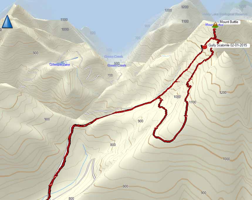
Total Distance: 19.2 km
Starting Elevation: 170 m
Max Elevation: 1390 m
Elevation Gain: 1419 m
Time: 7 hours
By 7:45 we were driving past Youbou and along North Shore Road. our eyes following the skyline of the nearby peaks examining them for evidence of snow, indicating the need to take snowshoes. We could see nothing! Even before we made our destination we made the decision to leave our snowshoes in the car.
Our hope was to make it to Marguerite Main, 14 km from Youbou down North Shore Road, and find the gate open. This would allow us to cut a few kilometres of logging road off the days walk. As to be expected, we found the red gate (n.12.0) locked, I parked the Subaru in a small lot across the road, level with the lake at 180m. Though the conditions did indicate the need for them, we kept our crampons and ice axes with us.
We hopped the gate and made our way up the logging road. The road is in remarkably good condition. If the gate was open a person in an all-wheel drive vehicle would find it easy to drive the road. However, they would only get about 3 km up the road, where a small rock-slide would stop most from passing. The road is well traveled by humans, elk and bear. There is plenty of scat and a fair amount of quad tracks. The quads can easily bypass the gate via a ditch beside it. These narrow wheel base of these small 4×4 vehicles would easily make it well into the hills and down many of spurs in the area.
We hiked 7 km up the road to 930 m. There road winds its way up the steep hills and twists through the valley, past multiple forks, eventually leading to the point were we entered the bush. Walter’s route indicates that he followed the road to its terminus, ascended through a clear-cut and eventually traversed by the sub-peak before achieving the main summit. His return was more direct to the road. From the saddle between the two peaks, he hiked straight down the hill to the road. If given the chance to hike through forest, rather than logging road, I will almost always chose the forest. We decided to go up the way Walter descended, up up and away!
We searched for an entry point into the thick brush. A dry waterway provided a small opening into the dense vegetation. If the undergrowth was verdant with leaves I’m sure we would have been turned back, unable to pick our way through. If one wanted to simulate the experience, find a tall cedar hedge with sturdy unyielding branches. To make the simulation even more authentic, be sure to spray the trees with water until the boughs drooped under the weight. At this point, walk through them over and over again. This is what the first 200 metres was like. we gained 50 metres of elevation slowly and we were able to pick our way through the area, avoiding small bluffs. The vegetation helped to stabilize us as we yarded on the limbs of trees, belaying ourselves up.
 |
| The route up the dry waterway |
Before too long, the dense brush gave way. Large first growth (possibly second) hemlocks replacing spindly alder and cedars. Further, the ground opened up, thick soft humus, replaced slippery logs, rocks and broken remains of trees. From here we gained altitude up the steep hill quickly. Eventually we found evidence of Walter’s route, we spotted 6 ribbons spread across the entire hillside. They reassured us that we were picking a route that would go, but didn’t provide enough guidance to be able to follow.
Though we had a GPS track, we didn’t follow his route entirely. GPS routes often get tricky to follow because of built-in inaccuracies with the device and the dense cover of the forest. Regardless, I imagine he used some of the rocky areas to make his way but we avoided these, as by the time we made it to 1100 m the weather changed from heavy rain to water-loaded snow. We were both soaked before we made it to the saddle (about 1300 m) but we were still warm with our effort.
As we worked our way north from the saddle to the main summit, it looked as though there were a few footprints –human– in the snow, though I can’t confirm this. The route from the saddle has some exposed sections, requiring a few simple class four moves along cliff edges but nothing overly death defying. We made it to the summit at 1380 m, just before noon. Examining a terrain map, the summit would likely hold an amazing view, we wouldn’t know. The heavy snow and low cloud allowed for no view. We posed only long enough for some photographs at the tiny cairn but didn’t stay long. The wind picked up and because we were both soaked a chill ran through me. I put on a few extra dry layers and changed my gloves before we hightailed it out of the strong winds.
 |
| Phil at the summit Cairn |
 |
| A shot from the summit of Mt Buttle, beautiful! |
On our return trip we decided to traverse across the saddle and the sub peak to find our way down the mountain toward the clear-cut section and the old logging road. This route is a lot easier to find. I can’say that we were on a defined route, however I would say that it was relatively easy to find a way down. We followed animal trails and our intuition as we descended. It was remarkably easier than the path we took up. I would venture to say that it was not only easier with less exposure but it was also faster because there was less route finding.
We made it to the terminus of the loging road at 1 PM, it only took an hour to descend from the summit a to the road at 1060 metres. We snacked here, out of the cold. The road here is even in good repair, wit honly a few spindly alder. The remainder of the hike was a simple return hike along the route we followed up. We arrived safely back at our car at 3 PM, just in time for the sun to come out! GAH!
A few days after the hike I was chatting with Linsay Elms regarding the ascent, we compared some notes about the route we each used. He climbed from the McKay Creek side in a much shorter time; he found an open gate. He suggested that Phil and I may have the first winter ascent of Mt Buttle. I mentioned the mysterious footprints and the possibility of ski tracks(highly improbable). Linsay and I conquered, it was likely a Sasquatch on skis, a Lower Island Sasquatch, smaller and less smelly than its Kootenay kin.
View all images…


Comments
This is a locked gate for a reason my family owns the property on the mountain side along the creek. Keep out for a reason sir. Your on camera and we aren’t taking this lightly. To many people have trashed the roads and illegally hunt all over it and because of that and other reasons we will take legal action if your cought. Don’t care if your a bird watcher or hiker or what ever your not welcome. Will be blocking any easy access around gates.
Well there “Unnamed” person above… challenge accepted. Will be heading here this summer!