
At the end of July, I led a group of five Island Mountain Ramblers on a mountaineering adventure to summit Elkhorn Mountain and Elkhorn South Mountain, both in Strathcona Park. I was excited to lead this trip for my club mates, a reprisal of a similar trip I did last year with another friend.
At 2195 metres, Elkhorn Mountain is the second-tallest peak on Vancouver Island. It’s a fun ascent which requires a variety of mountaineering skills. Though it’s not a simple peak, it’s not overly challenging, and the reward is phenomenal. The view from the summit is among the best on Vancouver Island: it looks down into the Elk River Valley, Landslide Lake, and Foster Lake, and has one of the best views of Mount Colonel Foster. Although we successfully summited both mountains, our success was overshadowed by my poor leadership choices throughout the trip.
These were not dramatic choices; rather, they were minor decisions that, nevertheless, bring to mind phrases such as “slippery slope” and “death spiral”. These phrases describe how a seemingly insignificant decision in an innocuous situation can lead to bigger choices and potentially dangerous situations. Reflecting now on my errors, it’s easy to see where I went wrong. It started at the trailhead as we prepared for the hike. Although I questioned the participants about their personal gear, my focus was on the safety gear: ropes, helmets, mountaineering axes, protection. I failed to ask about some more basic pieces of gear, and didn’t bat an eye when one of the members announced he wasn’t bringing a sleeping bag. Instead, to save pack weight, he was bringing a down jacket; since the forecast called for warm nights, and because DJ is an experienced mountaineer (certainly more experienced than I am), I didn’t pursue this point.[/cs_text]
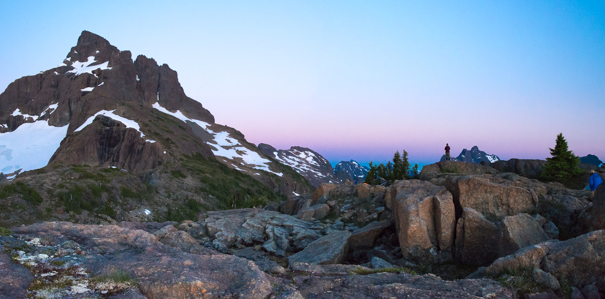
We followed the standard approach from the Elk River Trail to Elkhorn Mountain. After crossing the river, the trail follows a well-booted route through the old growth and up to exceptionally steep forest. Where the route became steep, we took breaks, conserving our energy for the exposed forest sections and scaling the wet mossy rocks, the final obstacle before the North Col. We reached the North Col (~1300m) by 3:00 pm, but didn’t stay long before continuing southeast, along the southwest face of the long ridge, to gain the alpine ridge. Farther along, we climbed up to a flattop (1700m) with a minor water supply. I felt great about our progress, and smug about my planning; we arrived at our camp on time, to the minute even!


Bathed in the warmth of the evening sun, we enjoyed a relaxing evening with plenty of time to set up camp and eat dinner before the sun set. I love camping on the flattop, because it offers an amazing view of Victoria and Warden Peaks. On a night with an excellent sunset, the peaks are silhouetted against the horizon while the surrounding mountains create visible layers in front and behind them. The first hint of a problem came as the sun touched the line of mountains in the distance, and a cold wind started to blow.

The wind came on strong and cold, pushing against our tents with enough force that I double-checked my guylines and added extra rocks. Phil retreated to his tent to avoid the wind, but I tried to hold out for the sunset. However, I soon gave up and retreated to the warmth of my sleeping bag. The cold wind blew through the night. As I lay awake, listening to the wind against the tent, I thought about DJ: What would it be like to sleep in these conditions, without a sleeping bag? In the morning, I learned the answer: he wasn’t able to sleep. A combination of cold temperatures and the flapping of his bivy sack kept him awake. He was tired!
Summiting Elkhorn & Elkhorn South
Day Two started well. Clear skies prevailed, and the cold wind of the night before was gone. The planned route took us up Elkhorn’s northwest ridge to the left of the gendarme, along the west face below the summit, and then up a gully to the summit. We would then descend and traverse the west basin, and drop down the choss-filled gully toward Elkhorn South Mountain. I expected a twelve-hour day, with our planned camp at the col between the two mountains; I was looking forward to the view from the saddle. Further, camping here would put us in position for the hike down to the trail and out the next day. However, the plan had one flaw: the evening forecast called for rain and a small possibility of thundershowers, and our planned campsite was very exposed.

We ascended the Northwest Ridge route to the step below the gendarme. Phil climbed the short, exposed pitch of low-fifth class, and threw a rope down to top-belay the rest of us up. We were slowed only by our numbers; it takes time to move five people across the terrain. As Phil belayed the others, I explored the route around the outside of the gendarme, ultimately deciding to use the exposed snow slope on the left of the gendarme. The cold conditions of the evening made the snow perfect for using our mountaineering axes and crampons.
From the gendarme, we followed the easy class three route around the west face of the summit block, gaining the summit in time for a noon lunch. The conditions were good, with a few clouds in the sky framing the Elk River Valley and Colonel Foster. We spent a considerable amount of time on the summit, chatting with a surprise guest. Tyson had climbed up and over the gendarme, using the regular Northwest Ridge route to gain the summit only moments after us. He had traversed from King’s Peak, following the ridge and descending into the basin below – exciting stuff!

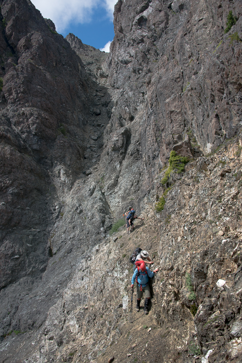
It took us longer on the return to our gear than it did to ascend, because we wasted time looking for the west couloir route. After 45 minutes of fruitless searching, I decided to descend the way we came up. Our descent below the gendarme was slow, as the snow on the route was less than ideal. The hot sun made the surface snow slushy; but, only an inch below, the harder snow resisted, creating slippery conditions that made plunge stepping difficult. Further, though I’ve descended steeper slopes with confidence, the lack of run out encouraged me to ensure my axe was penetrating deep into the surface with each step. At last we made it down, with me tripping over the newly-acquired tether for my axe. The route back to the bags was slowed even more when our ropes got stuck after a rappel; it was 2:30 pm when we arrived back at our gear and repacked our bags.
Though the clock was running, I wasn’t worried; the route from our position to Elkhorn South Mountain required no route-finding. We crossed the west basin, below Elkhorn’s massif, and used the steep choss gully to descend nearly 130 metres, then crossed the exposed gravel ledge to get to the base of the mountain. We paused around 1600 metres for a break, and considered our options. After discussion, we decided to drop our gear and pursue the summit with lighter bags. Our new plan was to avoid camping on the ridge, for fear of high winds or lightning. We were all exhausted, mostly from the heat and the long day, and we held a slow and steady pace as we climbed the gentle slopes of Elkhorn South Mountain.

Once on the summit, we could see dark foreboding clouds behind Colonel Foster – and they were moving in! The clouds threatened to bring the thundershowers that had been noted as a minor possibility in the forecast. Once we descended off the ridge and back to our gear, I made my biggest mistake: I allowed the participants to convince me to hike down to the gravel flats. It was already 6:30 pm, and we had been on the move for eleven hours. I expressed my concerns about the late hour, our state of fatigue, and descending an unknown route over unfamiliar terrain. However, I didn’t try hard enough to make them listen; they were driven by a desire to get off the hill in case of rain, and they didn’t want to sit around camp for a few hours when they could be walking. As the trip leader, I should have put my foot down: we should have stayed at the first flat spot below the summit ridge. Instead, we carried on.
It was a shitty end to a great day.Lisa

Descending from Elkhorn South to Elk River

The route down is varied. Light bush starts just below the alpine areas, leading to a series of bluffs that took some time to navigate around. Eventually, the bluffs gave way to open old-growth forest. We were lucky to pick the correct set of gullies to walk between. Periodically, we came across old ribbon, but not enough to follow – there was a lot of route-finding to do. We zig-zagged down the side of the hill between the two water courses, following the path of least resistance, changing direction only when we started to descend the steepest terrain back into a gully.
With several hours of walking and route-finding left, and the sun showing the first signs of weakening, the final bit of bad news was delivered to me. One of the participants didn’t bring a headlamp, having left it in a different backpack. We needed to get down and across the river to the main trail before dark. I was stuck between a person who was plowing ahead quickly, racing the light, and two folks that needed to go very slowly in order to be safe over the varied terrain.
I only managed to hold the group together for another hour. By dusk, we had spread out by more than 100 metres; in the thickening bush and failing light, it was impossible to see one another. We could just make out the terrain ahead of us, and HL announced his intention to go ahead, alone, to get across the river before the last of the light was gone. This wasn’t acceptable! I decided to follow close, to ensure that there were at least two people together at all times. Of course, this meant leaving the other group of three on their own. I was annoyed, but not worried; two of them had GPSs and topo printouts of the area, and at least two of them have significant backcountry navigation experience: I’ve done more than 30 trips with the pair of them.
By the time we pushed through the thicket of alder at the river’s edge, the sun had dipped behind the mountains and night was falling. We removed our shoes and socks, and crossed the shin-deep water to the other side of the river, where we were met by the blanket of night. The cloudy sky blocked the stars and moon, creating an endless abyss of black: the kind of dark where you can’t even see your hand in front of your face.
Once across the river, we heard the others crashing through the bush toward the river. We called out to them, but it didn’t help. At this point, the two of us pushed through the bush toward the trail. I don’t love bushwhacking at the best of times, but I don’t hate it; however, I hated this. At least in the light, you can see three feet, and choose a path of least resistance. This was a shitstorm of branches. I can’t even really call it navigation, as there was no possibility of forming a reference point. We pushed directly through, often breaking branches that clawed at our backpacks. We kept the river at our backs, and eventually bisected the Elk River Trail.
When the others arrived, 15 minutes later, I caught an earful. I could hear the distress in their voices as they shared their frustrations: they didn’t enjoy being led into the dark, and then left to travel the final kilometre on their own. They were safe, but they felt abandoned. I was disappointed in myself, and frustrated about the lack of control I had of the situation. I was further frustrated because we were still not finished hiking! We had to find the gravel flats, and I didn’t have an exact location for them. We had descended very close, but we didn’t know if we had to travel north or south on the trail.
When a ten-minute exploration in either direction didn’t yield the gravel flats, we hiked south toward main trailhead, knowing that we would eventually cross one of the campsites on the way. We were right: sometime after 11:00 pm we found the gravel flats and quickly set up tents. Some of us skipped eating before hitting the sack. We had been on the move for 16.5 hours, and the end of the day was a disappointing end to an otherwise amazing trip.
Adding insult to injury, the next morning brought beautiful weather conditions; there was no evening rain, and the sky was brilliant blue. Had we stayed in the alpine, we could have been well-rested, and spent the day leisurely descending through dry forest. It would have been my preference.
This trip was riddled with minor issues that became big problems. My decisions and actions are sure to be criticized by others. I made mistakes, the biggest being my lazy leadership: I should have demanded that the group stop and make camp, taking the risk of descending through wet forest the next day. This would have solved navigation problems, prevented issues with the missing headlamp, and kept morale higher. At no time was anyone in significant danger, however, I failed to meet the emotional needs of everyone in the group.
We were fortunate that we made it safely to the campground without injury. I learned some valuable leadership lessons: on these bigger trips, we need time to pack our bags so I can check everyone’s gear.
Comments
Pingback: Elkhorn Mountain - ClubTread Community