In search of what is sure to be our final snowshoe trip of the season, I set out on a mission with three other Island Mountain Ramblers. We braved a long logging road approach up Buttle Bluffs Mainline to reach camp for our summit of Alexandra Peak the next day. Alexandra sits outside the official Strathcona Park boundary; it’s in the range of peaks to the northeast of the commonly-hiked Mount Albert-Edward, across the Oyster River. Phil and I had attempted this peak earlier in the season, but the trip was ill-fated: the weather turned on us, the snow condition was terrible, and we turned back before even reaching the end of the Buttle Bluffs Mainline. We approached this second attempt with stern resolve – we would not be turned back.
 |
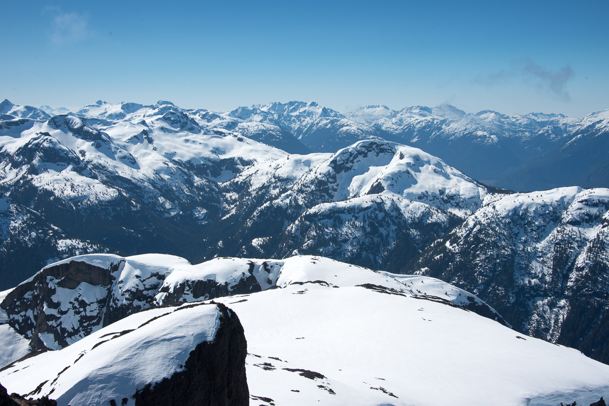
| The cirque below the Alexandra Ridge |
The Buttle Bluffs Mainline, eight kilometres of logging road off Highway 28 that gains ~1000 metres as it switchbacks its way up the mountainside, is the most common way to access Mount Adrian and Mount Alexandra. The road is gated, but those who drive 4x4s can bypass the gate on the right. The road is infamous for its narrow track: while driving it, you squeeze your vehicle between the edge of the road and extreme drop-offs. (
more about this road).
Total Distance: 24 km
Starting Elevation: 250 m
Maximum Elevation 1982 m
Elevation Gain: 1913m
Time: overnighter
As we couldn’t secure an appropriate vehicle for the long approach, we would be doing it on foot. This is just as well, as winter hadn’t been kind to the road. There are sections with large debris strewn across the width of the road, making it too narrow for vehicles to pass. In other sections, the road is considerably washed out. An ATV would make the trip, but there are a few sections where extreme caution should be taken. A high clearance 4×4 may make it to just before the waterfall on the road, near 700 metres of elevation.
We hit the long dusty road just before 5:00 pm on Saturday, April 9th. Bypassing the gate, we walked in the unseasonable heat, 21 degrees, of the late evening sun. Our packs were extra heavy. The road bare, we strapped our snowshoes to the outside of our packs. We anticipated using them before reaching 800 metres of elevation. We were so wrong.
 |
| Waterfall beside the road |
The road is relentless! The steep switchbacks tired us, and the long traverses played a psychological game with us. Like some kind of mirage through the heat shimmer, we could see our route far off in the distance. But the farther we walked, the more we could see it stretch even further ahead. Our goal was the end of the logging road up the Buttle 300 spur to 1200 metres. This would position us below the start of our route for the next day’s hike.
I felt sluggish, heavy under the load, belly full of Subway, and sweltering in the heat. Nevertheless, we made good time. Within ninety minutes, we passed where we had expected to find snow – but snow didn’t appear until beyond 1000 metres. As we rounded the final sharp corner, we were faced with the long descent into the valley between Adrian and Alexandra. The sun was dropping below the ridge of mountains at our backs, and we were chasing our shadows. Though we had hiked for just over two hours, we decided to make camp at the higher elevation on an old spur, just one kilometre from our intended destination. This allowed us to set up camp in the twilight, and would save us the effort of carrying our heavy bags down and back up the long hill.
What little view we had didn’t last long before the sunset. As we lost the light, the unseasonable warmth gave way to a cool breeze, and a cacophony of frogs echoed through the clear-cut. Soon, weariness took us to our beds to rest for the next day’s adventure.
We rose before the sun at 6:00 am. The dark grey sky betrayed the sun coming up behind Alexandra Peak. We struck our camp, packing it safely in protective bags with rocks on top, before descending down the road. We started the descent in snowshoes, save for Rishi; he had gambled by leaving his snowshoes in the car. We followed the road down into the valley between Adrian and Alexandra, up the Buttle 300 spur and into the treeline visible below the bluff that forms the skyline.
 |
| a view up the gully, the cirque above |
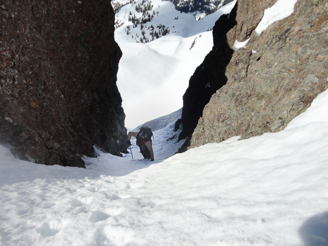
A dense ice crust had formed on the snow overnight, making an easy crossing of the old logging slash to the tree line. We snowshoed toward the main gully, toward the south bluff visible from the Buttle 300 spur. At a distance, it looks indomitable; however, as it exits the dense hemlock the route opens into a gentle, broad snow slope. In the shadow of the mountain, we ascended along the gully, which was hard-packed ice crust throughout. The gully narrows as it climbs; by the time I reached the last 50 metres, I was wishing for my crampons. I lost confidence in my snowshoes alone, and brought out my mountaineering axe. Even with my aggressive MSR Axis snowshoes, as I looked down the hill between my legs I wondered what self-arrest would look like in snowshoes. Phil, on the other hand, confidently used only poles to reach the lip high above.
Phil was the first to pop over the lip at the top of the gully. As I heard him utter a string of expletives, I worried about what I would find when I joined him. When I popped over the lip (~1650m), I understood. The cirque below the long summit ridge is a broad, rolling plateau. Today it was blanketed in heavy snow, which practically billowed over the landscape. Adding to the geography, the sun glinted off the snow, the main summit ridge, and the distant hills, creating an amazing view. The chill of climbing the shadowed gully disappeared with a few moments in the sun. Only a small shadow, created by the ridge, remained; we would be chasing the shadow up the steep snow slopes to the ridge as the sun came around the mountain.
 |
| the thumb, commonly used as the standard route to Alexandra Peak |
From the trees, the gully gains more than 400 metres. Upon reaching the plateau, we had already gained more than 650 metres. Tired from the evening before, we were struggling, and were less than two hours from camp. Phil and I were soon joined by Rishi and Rick on the plateau, and we discussed our options. There were three possibilities and we chose what looked to be the easiest, walking northeast of the gully to the left of the long summit ridge. Our eyes focused well above the snow in front of us, on a small saddle on the ridge 100 metres above, and the steep snow slope that reached it. We paused at the base of the slope and transitioned to crampons and ice axes.
 |
| The small gendarme on the right, where we ascended to the upper ridge |
We had a GPS route to work with, which travelled through the saddle to the backside of the ridge above, and then southeast to the inviting ridge on top of the sheer cliff of the mountain summit. We started strong, but before long we were grovelling with hands, knees, and feet on the steep slope. At the upper reaches of the slope, I plunged my axe deeply in front of myself and forcefully kicked through the dense ice crust to the softer snow beneath, creating positive steps that traversed the steep slope to meet up with the final 10 metres of bare ground that led to the saddle above. Even with the great conditions, including an obstacle-free run-out, I was grateful to put my feet on the moss and light gravel of the gentle slope.
 |
| Rishi ascending the steep slope to the ridge above |
 |
| we passed to the right of the bump |
 |
| Looking down on Rishi and Rick, the world beyond |
Phil was the first to reach the saddle and peer over (~1800m). I called up for his assessment. His only response was, “Wow, now that’s exposure!” Upon seeing the view for myself, I agreed. The drop off is extreme: we could see the valley more than 200m below the edge. By the time I reached the rim, Phil had already progressed to the crux of the climb: he was 3/4 of the way up an exposed section of rock wall, still wearing his crampons and brandishing his axe. He jammed his hands into rock crevices and drove the pick of his axe into the snow to haul himself up, unfazed by the exposure that accompanied the scramble.
 |
| there’s Phil, scrambling up the rock shelf! |
I’m not as brave as Phil. I removed my crampons and stowed them in my backpack before approaching the rock. This final section leads to the ridge above – we were so close! The conditions created more of a challenge: verglas had formed in a few key areas, snow pack covered some hand and footholds, and typical Vancouver Island rock crumbled when grabbed. Further, my aversion to exposure and my stupidity created bigger challenges. I should have put my camera in my backpack; around my neck, it prevented me from getting close to the rock.
The problem area is short, less than five metres in height. In a different season it would be easier, but today it required rock gardening and careful placement of hands. Cursing to myself over my stupidity, I jammed my open hand into a crevasse to my right and mantled off my left hand, raising my boot to a small foot-hold, then stood up. Careful placement of boot was important to avoid icy steps. It was only two or three moves to reach the shelf above. Although it is not difficult, if you’re not comfortable with exposure and scrambling, this route is not for you.
I sat on the rocky ledge (~1820m) and reequipped my crampons before heading out for my reward: the wind-shaped summit ridge. I could see Phil waiting for me, silhouetted by the blazing sun behind him: he was well ahead on the rolling slope. With just 600m of horizontal travel and another 150m of elevation left to gain, we paused to admire Alexandra’s rolling snowcap. It was wind-battered, scalloped but still icy, even with the sun beating on it. The real reward, however, was the view on either side of the narrow ridge: endless mountain ridges created a Ted Harrison-esque landscape of snow-capped ranges.
 |
| Looking back on Rick, contemplating the climb |
 |
| Phil on the summit ridge, Alexandra Peak |
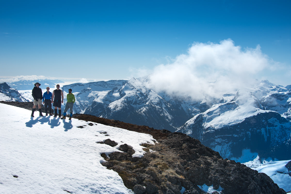
Phil and I waited on the summit. Looking back, we expected to see only Rishi approaching, as Rick had decided to wait in the col below. However, Rick had changed his mind and made the scramble! The four of us stood on the summit, giving each other high fives, taking photos, and admiring the views. It was 11:30 am.
We took our time admiring the 360-degree view of the ridges beyond. To the west, we saw the Cervus-Wolf Dive (a route that Phil and I have scheduled for July). To the east, across the Oyster River Valley, we could see Mount Regan, Mount Jutland, and Mount Albert Edward, including the long snow-covered ridge. I’d never seen them from this angle; the familiar mountains looked so foreign. The conditions were stunning. Rishi said it right, as he was posting his summit shot to Instagram: “Guys, I’m having trouble finding the right emoticon to express how this feels right now.”
 |
| stunner of a view from the summit |
 |
| I set the timer and hauld ass for this shot. That’s Albert Edwards’ long ridge behind us |
After conferring, we chose to descend via the standard route, rather than downclimb the exposed section of rock we’d come up. From the summit, we only needed to walk a few meters before the rapid descent down the gully to the col between the thumb and the main summit ridge. My understanding is that many folks go around the thumb, but we took the direct route, down the steep snow-filled gully below.
Phil led the way, using ice axe and heavy foot to kick good steps down to the entrance of the gully. At the base of the thumb, the gully terminates in a broad, open snow slope; it was exposed to the afternoon sun, making it soft and perfect for walking. In fact, even better, it was perfect for sliding! I sat and glissaded. It took a lot of force to slow myself with the pick of my axe as I descended. I stopped midway down the slope, stood, and briefly looked behind myself to see Rishi preparing for his glissade. A moment after I started down, I heard Rick shout, “Watch out, Matt!” I could hear the distinctive whoosh of snow and ice, and turned just in time to step out of the way as Rishi raced by. I have no idea how fast he was going – it was obvious he was entering into an uncontrolled slide. As he rushed down the slope, his trajectory took him straight to a bumpy section. He hit a large bump, sending him soaring three feet in the air; with his ice axe thrown to the side, he hit hard and finally skidded to a stop about 100 metres below me.
 |
| Phil kicking steps down, between the thumb and the summit |
 |
| Me! descending to the col between the summit gully and the thumb |
The worst thoughts went through my head, and I was ready to pull my rescue beacon. I held my breath, waiting to see if he moved. Fortunately, he immediately stood up and gave a little wave. We all converged on his location at the bottom of the slope. He was scraped, bruised, and had a sore ankle: otherwise, he was okay. With a little gauze, Polysporin, and self-adhesive tape, he was soon patched up and we continued on our way down.
 |
| The long road back to get our snowshoes |
The trip back to the camp was quick; we arrived before 2:00 pm. The final gully leading back to the Buttle 300 spur is in near perfect condition for walking and glissading. At the bottom of the gully, we put our snowshoes back on – except for Rishi, as he left his in the car to save weight. This cost him some time, and caused frustration: Phil, Rick, and I were back at camp well before him. His only comment, however, was one of acceptance: “Having snowshoes won the day.” In the lowest sections of the valley, he had been caught up to his waist in snow a number of times. From my perspective, it was well worth carrying my snowshoes for 16 kilometres.
As we descended back to the car, the skies were a patchwork of cloud and sun. We were warm enough, but the cloud spared us from the full brunt of the afternoon sun. I won’t call the return eight kilometres of logging road enjoyable, but the views of the snow-capped mountains across the lake were magnificent.
We arrived back at the car by 4:30 pm. I was happy to strip my hiking clothes off and dress for the drive home: I made it home in time to give Hemingway his bath and put him to bed. A great day in the mountains, and a little family time at home. An Island Mountain Ramblers trip I can’t forget.
See full album of photos


Comments
Pingback: Cederstedt Mountain: Introducing the Ditch Muncher – Island Mountain Ramblers