
The Juan de Fuca Trail is one of my favourite Vancouver Island Hikes. It’s a forty-seven kilometer A-B hike that requires some coordination in order to make transit back to your vehicle easy. One of the great aspects of this trail is that it provides multiple options for hiking, there is four trail heads along the route that give access back to the highway. In this way a hiker could chose to hike one or more segments in a weekend or even have an escape route if they got in trouble. You can find the official parks map here.
I have hiked this trail in its entirety 5 times, including this hike. The most enjoyable way for me to do this hike is taking 5 days, though this time I did it in four and it wasn’t much of a stretch with the long summer days. Other hikers definitely do it three days, though I suspect they verily run through certain sections and of course trail runners do it less than 6 hours.
 |
| Click here for GPS Route with more photographs of the trail |
Distance: 48 km
Metres ascending: 3300 m
Max elevation: 300 m
Nights: 3 days
As I always plan, my friends and I hiked this trail from the southeastern trailhead at China Creek, west to the Botanical Beach trailhead near Port Renfrew. I do it this way so I can get the most challenging sections of the trail behind me early in the trip when my legs are fresh. For this trip I made some significant upgrades to my kit, which resulted in a much lighter pack, only about 19 pounds; this includes food and water, though my digital camera is always an additional five pounds.
My female hiking partner, lets call her Ms. VW, and me left Nanaimo at half past noon on Friday. The conditions were sunny, the roads were dry and the drive through Cowichan Lake region to Port Refrew was quick, around two and a half hours. We met the third member of our small party in the parking lot for Botanical beach, the western most trailhead and the official end of the trail ant kilometer forty-seven. We left Will’s SUV in the parking lot at Botanical Beach and took Ms. VW’s car to the China Creek trailhead.
 |
| Suiting up for hiking on the first day at the China Creek trailhead |
On the way to China Creek we stopped at the Coastal Kitchen Cafe to load up on protein and carbohydrates for the day’s hike. I ordered a Coastal Kitchen burger, it didn’t disappoint. The burger was loaded with crisp vegetables, a hearty serving of potato chips and served quickly, considering the number of customers in the restaurant.
 |
| An example of the twisty trail |
The drive from Port Renfrew to the China Creek trailhead is almost 45 minutes. By the time we arrived at the trail head it had started to drizzle so we suited up and were ready to hike by 3:45 PM. Our first day of hiking was short, only about 3.5 hours including breaks. The first section of trail descends quickly China Beach where you get your first glimps of the ocean and treated to many sections of what this trail has to offer on the wild west coast. Day one is mostly downhill with only a few sections of uphill that are easily manageable.
 |
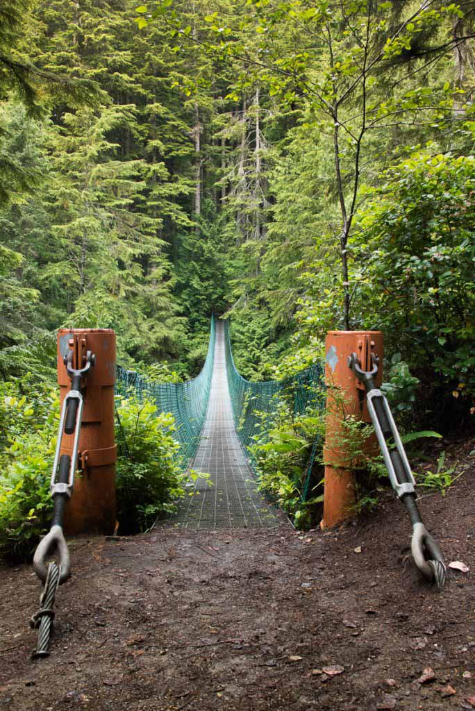
| First Suspension Bridge on the Trail |
 |
| One of my favourite trees, twisted and gnarled |
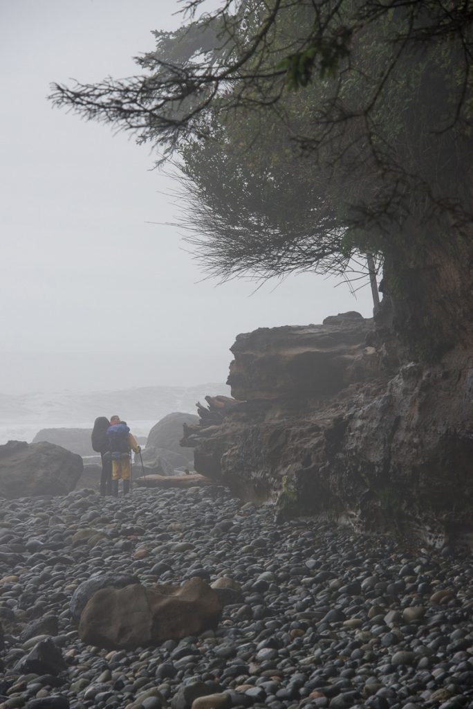
We stopped at an area that is easily identifiable as camping area, several sections of clear land, cover from wind and water for drinking readily available. Though this spot sits right before a high tide cutoff point, the tide predictions indicated we would have no trouble passing in the morning.
 |
| Balancing Rock at the end of Bear Beach |

The first night was not awesome, I barely slept. It rained most of the night and I found it hard to sleep with the noise. Further I did a piss-poor job of selecting a site for setting up my tarp system. On one side I had water splashing back onto me and my bivy sac. Worse, apparently when I setup my system I failed to note that I was in a shallow depression in the land. During the night I put my hand on the ground to adjust my position as I slept and was greeted by about and inch of water beside my bivy/mattress combo. Fortunately my mattress is 3 inches high and kept me well above the water and I somehow I managed to avoid getting my sleeping bag in the water. I learned an important lesson about reading the ground before setting up the tarp system for sleeping under. The experience makes me reconsider my tenting options for the North Coast Trail in July.

When I awoke I was looking forward to the challenge of the day ahead, day two is considered the toughest section of this hike. Keeping in character with most coastal hikes on the coasts of Vancouver Island, this section of the heads inland and hits the beach only a few points along the 12 kilometer stretch. The aspect that makes this section the most brutal of the hike is the number of switchbacks that must be hiked in this section. Looking at the climb profile for day 2 it possible to see multiple peaks that require the hiker to as end almost 1000 meters on day two of the hike. We took our time, the weather was predictably unpredictable. One moment there was rain, so we would don our rain jackets but then the sun would come out , the rain would abate and we would fry…. for only a while and the rain would come again. We played this game all day.


 |
| Official Trail |
With the long summer days we didn’t push hard so we completed the hike in 6 hours, including breaks. We camped at kilometer 21, again this was a section that would be obvious for tenting. I can only describe it as an oasis. There is a big level green section just off the beach with a stream running through it. On this day there was easily 15 tents in the treed section, seeking shelter from the wind, using the bear cache and pit toilets. Although it was a bit crowded there was still space and I was still able to feel as though Ms VW, Will and I were hiking and camping mostly alone.


 |
| Chin Beach to Sombrio Trailhead, Climb up these rocks Official Trail |

 |
| Will considers, “If I jump, I won’t have to hike the final kilometers today….” |
With the toughest part of the trail behind us and a desire to hit Sombrio Beach before the next wave of campers hit the beach, we woke early for day three. Sombrio is notoriously cramped. It’s a large beach but it’s a trailhead and with surf breaking well before the beach, it’s not uncommon to find 20 or more tents on the beach, even in March or February! The morning was a dryer than the previous days but our tents were still soaked with condensation. As we packed up and strapped on our packs the sky was overcast but far off on the horizon Will pointed out the blue skies that we all hoped for.
The section from Chin to Sombrio is one of my favourite sections along this trail. At many points I often recite the phrase Official Trail, in a sing-song voice because of the very real possibility to perish, where there would be no trace of what happened to you or evidence of where you went. It is also the second toughest section of the trail about 650 meters of elevation of gain, though it is spread out so the grade of each slope is less atrocious than the day before. Today, the mud on this section of trail was greater than the previous days, this slowed our progress. Around 10:45 the sun broke through the cloud cover and we hiked the remainder of the day in blazing sun. This improved our spirits and put a spring in our step, we hiked the 9 kilometers in about three and a half hours.
 |
| Surfers! |
 |
| a dog relaxing on Sombrio Beach |
We arrived at Sombrio just before noon, covering the 9 kilometers in three and a half hours. There were dozens of tents stretched across the several kilometers of beach with upwards of 40 surfers in the water. Once at the beach Ms. VW took a break, kicking off her boots to wait while Will and I hiked further down the beach looking for a spot that would accommodate our three tents, near a bathroom, have a food cache and close to our departure point. Even with all this criteria, we found a great spot on the western most point of Sombrio Beach proper, in the trees and just off the beach.
We dropped our packs and took a breather while we assessed our situation. The sun was high in the sky as it was just after noon, already we could see dozens of tents and likely than 100 people on the beach and in the water. Will and I decided we should push onto Little Kuitshe Creek. We took lunch on Sombrio and laid our tents, sleeping bags and anything else that was damp out in the sun to dry. I went back and collected Ms. VW. With minimal reluctance she put her boots back on and joined us on the west end of the beach.
After lunch we repacked our bags and continued on to the next leg of the hike, Sombrio Beach to Little Kuitshe Creek. This section of the trail is the most confusing, though not the most difficult. The challenge is finding your way from Sombrio back onto the trail. Because there are so many simple paths to Sombrio Beach from the parking lot it is easy to get lost. Further, once on the path it’s confusing where exactly to go because as you hit the end of Sombrio beach there is no signage directing you to hike up a muddy embankment. This must be the least traversed section of the trail as it seems the least official, lots of sections that seem as though you are just wandering along a 6 inch path in the woods, if you stay on track. We did the 5km in about 2 and and a half hours. Much of this section is inside deep wooded area where very little light penetrates, though I did manage to find a few very magical shots!
 |
| Seclusion |

The little Kuitshe Campsite is in a thicket of thin trees. I usually hike past this section because it seems more of a waypoint, rather than a destination. However this time it seemed placed at an ideal interval along the trail, perfect for the evening! The campsites are hidden throughout the trees. Light barely penetrates the cover but the sites very protected from the elements. We setup in a small clearing by the pit toilets and then wandered down to the rocky shelf well below the campsites. Here we managed to catch the last rays of the day, cook our meals and eventually join a large group of other hikers sitting around a small fire on the the rocky shelf. We hit hay early this evening, hoping for a good nights sleep for the final day ahead.
 |
| Jammed in the trees |

 |
| Rocky promontory where one can enjoy the dwindling light of the day |
Day four would see us hike the final 13 kilometers of the hike, the easiest too. The sun was out early in the day and the tides low so we were able to walk the slab rock shore to Payzant Creek, where we found a very overgrown trail up to the Payzant Creek campsite. With the sun out the reprieve of shade provided by the trees gave us pause long enough for us to eat our lunch before continuing on our way.
 |
| fog rolling in along the slab shores between Little Kuitshe and Payzant |
 |
| We interrupted this bear’s bath-time |
The final 5 kilometers went by fast, as did the entire day. The ground levels out and the trail starts to spourt boardwalk. In the dry weather the boardwalk offered fast safe travel, though I know in the rain the same boardwalks can be death! We arrived at kilometer 47, tired and hot. We wasted no time cleaning up in the parking lot and piling into Will’s SUV before zooming off to the Coastal Kitchen Cafe for some fish and chips and a cool adult beverage!
 |
| boardwalk |


All in all this trip was a great success. Though there were a few days of drizzle and the trail was muddier than my previous experiences, I always enjoy this section of Vancouver Island. I feel as though my gear is thoroughly tested and I can see some issues with my gear. Though I love the open air feeling of the tarp layout and the weight in my pack it does pose some risk for a longer hike. A three or four day trip would be easy with this kit. If I experienced a problem I could easily power through a hike in a shorter time. However, on an 8 day trip it could present as a serious liability to personal comfort and safety.
I look forward to my next trip, the North Coast Trail!


 |
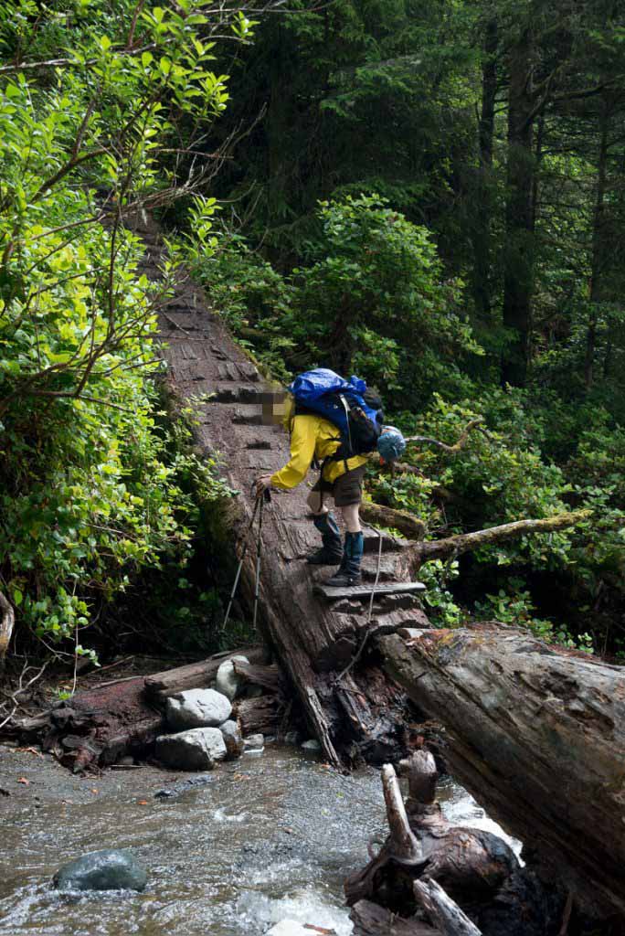
| this is a log bridge, Official Trail |


Comments
Great post! I have always wanted to do this hike and hope this is the year! What would you say is the best time of year to make this hike?
Thanks for contacting me. I’ve done this hike in every season. My all-time favourite times were in February and March. However, I valued those experiences for the solitude and not the sunshine. I was willing to trade the assurance of warm weather for a little privacy. Further, my muddiest experience on the trail was in a July. It’s a bit of a crap shoot, really. My best advice: do it in 4 nights. I enjoyed the luxury of the extra nights.
Great post! My partner and I are doing this hike this coming Easter long weekend. We plan to take 4 days with an optional 5th as I am pregnant and may be moving slower than usual. Just wondering as a precaution if you had cell service while on the trail (not that you wanted to use your cell phone unless necessary). Thank you!
Hey Jennifer,
Thanks for readhing out to me. There are some sections along the trail that get cell service from the Olympic Peninsula, make sure that you have your Roaming turned on if you hope to use it.
The first time I hiked this trail my wife and I met up with another pair of hikers. The female partner was 4 months pregnant at that time. I’m not going to lie, she was very tired on a few of the section.
My advice: Take hiking poles, there will be many uses for them.
Finally, if you have done a lot of backpacking before, I’m sure you will do fine. However, if you are doing this as your first backpacking trip, I’d recommend something different: Cape Beale from Tapaltos Bay. My recommendation comes from personal experience. My wife did a few backpacking trips while she was pregnant. With our first child, she was in better physical condition and it was a lot easier. By the time baby two came along the backpacking was a lot more challenging. A lot of factors played into this, I had to carry baby #1 who was nearing 30 pounds on top of the 35 pounds of gear; and upon the midwife’s recommendation, my wife was only permitted to carry 25 pounds and was advised to keep the belt very loose.
I would love to hear how this trip goes for you. Good luck!
Thanks again, loved hearing back from you so quickly! I will be heading your advice and plan to use hiking poles, I took them when my husband and I spent 3 months trekking around SA because of a sore knee and they were worth their weight in gold! I also used them last summer on the west coast trail and would tell anyone that they are essential on muddy slippery boardwalks and trails.
Yes a 20-25lb limit is what I have been reading so thank you for that info as well. This is our first pregnancy so we have yet to face the challenges of multi-day trips with littles.
I really appreciate your time and will definitely let you now how it goes!
Jen